
Our Catchments
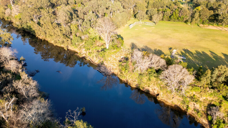
The Nepean River and Wianamatta South Creek are the two main catchments in the Camden local government area (LGA), with Narellan Creek being the largest tributary that flows into the Nepean River. These catchments, and their waterways, support wildlife, recreation, green spaces, urban areas and even the local economy. All the catchments and waterways in the Camden LGA drain to the Hawkesbury River, over 40 kilometres away.
The Hawkesbury-Nepean Catchment
The Nepean River is approximately 145 kilometres long and flows from Robertson in the Southern Highlands of NSW to the Grose River in the Hawkesbury. Here the two rivers merge to form the Hawkesbury River which flows another 120 kilometres into Broken Bay. With an area of 21,400 square kilometres, the Hawkesbury-Nepean catchment is one of the largest coastal basins in NSW.
There are several major towns that sit within this catchment area, including Camden, Narellan and Oran Park within our LGA, with all the rivers, lakes, wetlands, dams and stormwater infrastructure in our LGA eventually entering the Hawkesbury-Nepean River.
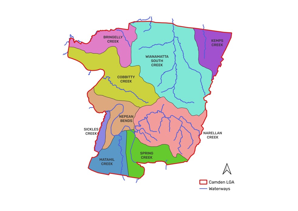
Sub-catchments
There are 9 sub-catchments that make up the larger two catchments within the Camden area. These are:
- Bringelly Creek
- Cobbitty Creek
- Kemps Creek
- Matahil Creek
- Narellan Creek
- Nepean Bends
- Sickles Creek
- Spring Creek
- Wianamatta South Creek
Partnerships
Camden Council works with residents, community groups, government agencies, and industry bodies to protect our catchments and waterways.
This includes:
Friends of the Hawkesbury-Nepean Waterkeeper Alliance
Camden Council is proud to be an organisational member of the Friends of the Hawkesbury-Nepean Waterkeeper Alliance and is committed to:
-
Healthy waterways in the Hawkesbury-Nepean;
-
Supporting the Hawkesbury-Nepean Waterkeeper Alliance in achieving its objectives and principles upholding the core vision for the river system;
-
Providing advice and expertise on priority challenges for the river system and its tributaries;
-
Being part of a unified voice and representative of the community; and
-
Celebrating the ecological and social value of the river and its tributaries.
![]()
Camden Council is a member of Stormwater NSW, a not-for-profit association focused on efficient stormwater management. They provide professional development through seminars and an annual conference and serve as a resource for stormwater professionals and the wider community.
Definitions
Alluvium – a type of soil or sediment that has been deposited by rivers or other running water. In freshwater systems, it is typically found in riverbeds and floodplains. It is usually made up of a mix of materials like sand, silt, clay, and gravel, and it's often very fertile, making it great for agriculture.
Bank toe – the point at the bottom of a river or stream bank where the slope of the bank meets the streambed or water surface.
Catchment – is an area of land where all the water that falls as rain drains into a specific river, lake, or common outlet.
Deposition – is the process where materials like soil, sand, and rocks are deposited or settled in a new location after being carried away by wind, water, or ice.
Erosion – the process by which soil, rock, or other surface material is worn away and moved to another location by forces like wind, water, gravity, or ice.
Fluvial – refers to anything related to rivers and streams, and the way they shape the landscape. It describes processes, features, and deposits that are formed by the action of flowing water.
Nutrient load – is the total amount of nutrients, like nitrogen and phosphorus, entering a waterway, which can affect water quality and ecosystem health. These can come from various sources such as agricultural runoff, sewage, and stormwater.
Riparian – refers to the areas of land that are directly next to rivers and streams, such as riverbanks. These zones are important because they often have unique ecosystems and play a crucial role in maintaining the health of the waterway and providing connectivity for wildlife.
Stormwater pollution – occurs when rainwater runoff picks up pollutants like oil, chemicals, rubbish, and dirt from streets, parking lots, and other surfaces, and carries them into rivers, lakes, and oceans.
Tributary – is a smaller river or stream that contributes flows into a larger river or lake.
Water Sensitive Cities – Water sensitive cities are urban areas designed to manage water in a sustainable and efficient way. They aim to use water resources wisely, reduce flooding, improve water quality, and create green spaces that benefit both people and the environment. Another common term is “waterwise city”.
Water Sensitive Urban Design – is an approach to managing stormwater and reducing the impact it has on waterways. WSUD is based on a scientific approach that is designed to integrate the urban water cycle with the built and natural landscape, keeping water in the landscape and providing environmental benefits.
Waterway – is a natural or artificial channel through which water flows. This includes rivers, streams, lakes, and any other paths that water travels along (swales, wetlands).